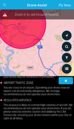
Working on the basis of an interactive map that shows the pilot their surroundings, zones are clearly marked out in circles of varying colours on the warning spectrum from orange to red. It has been developed in partnership with Altitude Angel – which is a UK company that seeks to innovate in the field of drone traffic management solutions, a company vision that has a long-term future focus – and also has the capacity to show ground-based hazards that can pose a safety or privacy risk, such as power lines or schools.
With the number of drone-related incidents on the rise particularly the well-publicised airport “near misses” that have temporarily suspended operations in Dubai and Heathrow before, the push to educate drone owners rather than to punish is clear. Most personal drone owners are unaware of the full range of restrictions and limitations – 60% in a recent survey by CAA – so engaging with the public in a free and interactive manner is seen as the best option. This comes on the back of the CAA and NATS updating their DroneCode as well as providing a dedicated website that lists the full details of the code of safety.

NATS
UK rules state that a UAV must be kept within the pilot’s visual line of sight, stay below 120m, and remain at least 50m from buildings and people, while in built up areas the minimum recommended safe distance is 150m. Drone Assist will allow users to report and share locations that are safe to fly a drone in, allowing the community to help each other out while reducing air congestion.

NATS
The app has been made available for iOS and Android for free from 3rd December.


.jpg)
.jpg)
.jpg)

.jpg)


.jpg)
