Genesis of the App
The use of drones in the UK is growing at a rapid rate. Unfortunately, we’re also seeing a rise in the number of safety-related incidents involving drones. NATS’ number one priority is safety so we wanted to be proactive and do something that would help drone users to fly safely. We felt providing an app, particularly one that was free to download, would be one good way of doing this so we partnered with Altitude Angel to develop Drone Assist.
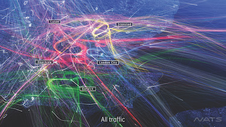
The app provides users with a map of the UK, overlaid with a range of airspace and other information that will help inform drone users where to fly. Users can search for an area they plan to fly and the app will show areas of controlled airspace or airports, warning users of the risks of flying there. It also shows temporary airspace restrictions (known as NOTAMs), so drone users can make themselves aware of other activities in the airspace that might influence their decision of where to fly, as well as ground hazards, such as power lines, schools or recreation grounds which may raise privacy or security concerns. In addition, there is a “Fly Now” function, which enables you to submit a flight report detailing where you plan to fly your drone and when, which will be visible to all other Drone Assist users, thereby increasing overall awareness of what’s going on in the airspace around you.
The app is powered by Altitude Angel, who obtain their data from a number of recognised official sources and then feed this into the app.
What Has Been the Response so Far?
The response to the app has been excellent, within the first 48 hours more than 2,000 people had downloaded the app and more than 500,000 views of ground hazards and airspace restrictions had been recorded. Feedback has been really positive too with a lot of people commenting on the fact it’s helping them to know where might be the best place to fly safely and where they might be best to avoid flying.
Is This Part of a Wider Push to Engage With the Public About Safe Drone Usage?
More people are using drones for various reasons, and while we want to encourage the use of this exciting new technology, we also want to see it used safely. There has been a significant increase in reported incidents over the last couple of years. Working closely with the CAA, NATS believes that through education and improving people’s awareness, we can help reduce the risk of further incidents and disruptions to airports.
We have close working relationships with the CAA and other organisations. Everyone is keen for drones to be used safely in UK airspace and we’ll continue to promote the safe use of drones.
How Effective Will it be at Reducing Drone Incidents?
It’s too early to tell if Drone Assist will reduce the numbers of reported incidents, but we hope it will be successful in helping to reduce the risk of drone-related incidents by giving drone users greater awareness of the airspace around them and what other activities might be taking place in it. Drones should always be kept well away from aircraft, airports and airfields and kept within sight of the operator. But also we hope the app will help people to understand ground-based hazards that might pose a safety or privacy risk, such as power lines, schools or sports venues.
What Other Methods Are Available or Likely to Become Available for Engaging With the Public?
NATS is always looking to find ways to engage with the general public in order to improve the safety of our airspace. We currently use many methods of social media, including Twitter and Facebook, our blog and Discover pages on nats.aero. We have the joint website – dronesafe.uk – which we launched recently with the CAA, which is supported by the wider UK aviation industry and we also have a webpage about our drone training courses for operators using drones for commercial purposes. Anyone wishing to find out more should visit www.nats.aero/services/consultancy/training/remotely-piloted-aircraft-systems-rpas-course/
We also support many drone events, including the Drone Show and RAeS Annual Drone Conference.
Can it Be Easily Updated With Any Amendments to the Regulations?
We will be continually looking at ways to improve the app. If there was a change to the rules of course we would look to ensure that the app reflected this in whatever way was appropriate.
The CAA regulates the airspace, our role is to support the safe use of our airspace by those who want to use it, whatever the regulations.
How Best Can the Regulations Be enforced?
We hope the app can help people understand how to use their drones safely in the UK. We’ve tried to keep the app simple so that anyone can benefit from it, regardless of their experience and their level of knowledge about how UK airspace is structured and managed. Both Altitude Angel and NATS will continuously monitor usage and user feedback to ensure safety information is conveyed in the simplest and most effective way.
Drone Assist is designed solely for people flying in UK airspace - although other countries, such as Switzerland, have introduced a similar app to help educate drone owners.
How Are You Making the Availability of This App Known to Drone Users?
Drone Assist is a free app and available to download on Android or iOS. The app has been designed to help everyone abide by the rules, identify areas of controlled and restricted airspace and help them enjoy flying whilst ensuring their safety and the safety of other airspace users.
We’re working with other organisations and companies, such as the CAA and Maplin, to promote the app and provide customers with information on the Dronecode and where to find the app at the point of sale when buying online and in stores.

For further general information on how to use drones safely we would encourage drone users to visit the DroneSafe website http://dronesafe.uk/ where they can also find a link to Drone Assist.
.jpg)
.jpg)
.jpg)

.jpg)